
GeoTrack360 works on iPhone and Android. Your company gets its access details from the GeoTrack360 team.
Download the app
Install it from your phone’s store and search for “GeoTrack360”.
Sign in
Open the app and enter your Email and Password. Turn on Remember my email if you don’t want to type it every time.
Tap Sign in. Your session stays open and closes by itself if your access stops being valid.
If you forgot your password, tap Forgot your password?, enter your email and you will get a 6-digit code valid for 15 minutes. Check your spam folder too.
Five tabs, everything at hand
MapVehiclesHistoryGeofencesAccount
Administrator
Sends commands, creates geofences, changes the speed limit and manages maintenance.
Viewer
View only. If you don’t see a button from this guide, ask your administrator.
LanguageSome screenshots show the app in Spanish. In Account → Settings you can switch to English and the screens use the labels shown in this guide.
2
Your fleet, right now
Live map
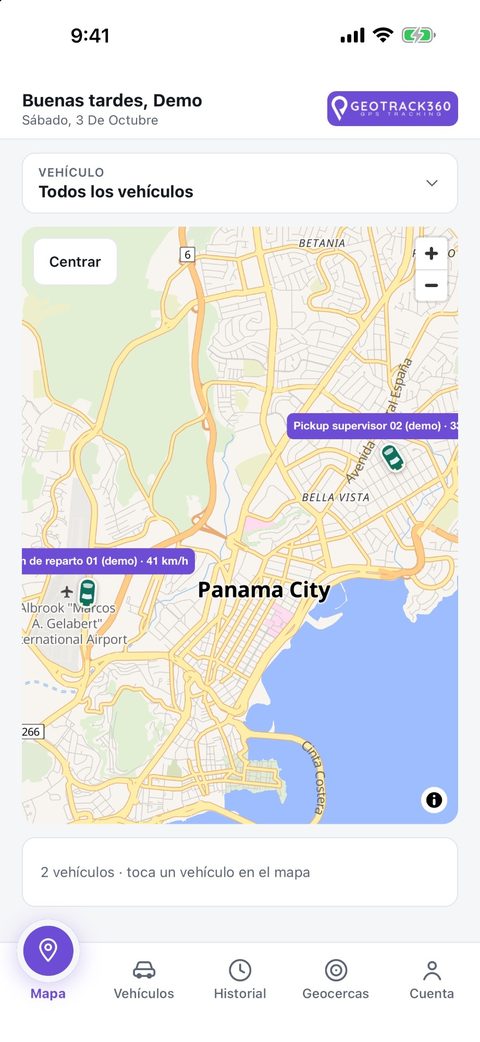
This is the main screen. It shows all your vehicles and refreshes by itself every few seconds while the app is open.
MovingShows its speed
StoppedParked, with signal
No signalNo recent data
Each vehicle shows its name and speed, for example Delivery truck 01 · 41 km/h.
The Vehicle selector lets you see All vehicles or pick just one.
Center frames the map on your fleet, and the + and − buttons zoom in and out.
Tap a vehicle to see its card with speed and time of the last update. From there, Details opens its full page.
What does “data from 20 min ago” mean?The device has not sent a new position, perhaps because it is in a garage or out of coverage. You see the last one received.
3
Every vehicle in detail
Vehicles and their page
The Vehicles tab lists your fleet with the status of each one. Tap one to open it on the map and go to its Details.
What the vehicle page shows
Current Speed and Ignition (On / Off).
Total Distance traveled by the device.
Activity for today or the last 7 days. Alerts appear first and routine activity stays collapsed.
Command history: who sent each command, when, and with what result.
Events you will see in Activity
Ignition onIgnition offStarted movingStoppedSpeedingEntered a geofenceLeft a geofenceAlarmDevice offline
TipIf a vehicle shows “No signal” for a long time, check that it has power and contact support.
4
Remote control
Vehicle commands
From the vehicle page you can send two commands. Only administrators use them, and they require an active subscription.
Request location now
Tap Send and wait for confirmation: you will see “Position updated”. If 60 seconds pass with no answer, use Check again.
Cut and restore the engine
Open the vehicle page and tap Cut engine.
With the vehicle stopped, press and hold Hold to cut the engine. It is recorded under your name.
To let it start again, tap Restore engine and confirm.
If it is moving or has no signal, choose Cut when it stops: the cut is scheduled and applied automatically once it stops, expires after 12 hours and you can cancel it. If the device is offline, the command is queued until it reconnects.
Emergency cut (optional)Lets you cut a moving vehicle and is disabled by default. It can disable power steering and brake assistance and cause an accident. An administrator must enable it by accepting a legal notice, and every use is recorded and notified. Use it only in real emergencies; it may not work at high speeds.
5
Routes and trips
Trip history
Review where each vehicle went, how far it traveled and how fast.
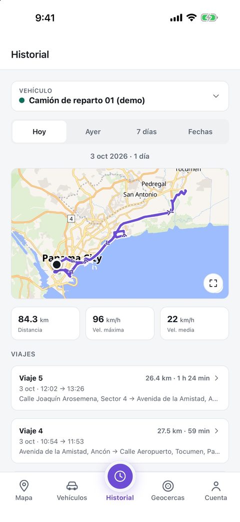
Open History and choose the vehicle in the selector.
Pick the period: Today, Yesterday, 7 days or Custom (up to 31 days).
You will see the route on the map and a summary with Distance, Max speed, Avg speed and the list of Trips.
Tap a trip to see departure and arrival, duration, stops of more than 2 minutes, a speed chart and events.
Export your reportsWith Export CSV or Export PDF you download the trip report for the period, for your records or to send to someone else.
6
Zones with alerts
Geofences
A geofence is a zone on the map, such as your workshop, a customer or a city. When a vehicle enters or leaves it you get an alert.
The Geofences tab shows a map of all your zones on top and the list below, with address, type and description for each.
The ones your company creates can be edited. Those shared by GeoTrack360 are read-only.
Create a geofence (administrators)
Tap New.
Tap the map to set the center, or use My location.
Enter a Name (up to 60 characters) and adjust the Radius.
Tap Save geofence. To remove one, open it and use Delete geofence.
LimitEach company has a maximum number of geofences. If you reach it, delete one to create another.
7
Alerts your way
Notifications
Get alerts on your phone when something important happens, without watching the map.
Turn them on
Go to Account → Notifications and tap Turn on notifications. If the system blocks them, use Open settings and allow them.
Choose which alerts you get
Ignition on / off
a vehicle is switched on or off
Geofences
a vehicle enters or leaves a zone
Alarms
the battery is disconnected, low battery, possible accident or fall
Speeding
a vehicle goes over your limit
Started moving / stopped
it starts or stops (can be many alerts)
Connection
a tracker goes offline or reconnects (can be many)
Maintenance
a vehicle reaches the mileage of a task
Speed limit and weekly summary
The administrator sets one limit for the whole fleet and taps Save speed limit. With Weekly fleet summary, every Monday you get an email with last week’s kilometers, speeding events, zone exits and alarms.
8
Everything else
Account, maintenance and fuel
Maintenance by kilometers
On the vehicle page, the Maintenance card reminds you of tasks such as oil changes.
Tap Add, enter the task and every how many km it repeats.
The card shows how many km are left or by how many it is overdue.
When you do it, tap Mark as done and the count starts over.
Fuel estimate
In Fuel you enter the price per gallon and each vehicle’s km per gallon. The weekly summary estimates consumption and cost. It is an estimate: it does not measure actual consumption or detect fuel theft.
Your account
Profile: your name for the greeting on the map.
Language: English or Español, applied immediately.
Password: at least 12 characters.
Subscription: plan, devices in use versus contracted, and the date the service is paid through.
Subscription noticesA banner warns you when it is about to expire. After the grace period the service is limited: you can still see the map but commands are turned off. To renew, use Message on WhatsApp on the Subscription card.
?
Got questions?
Frequently asked questions
My vehicle shows “No signal”.
The device has not sent data recently. It usually happens in garages, tunnels or areas without coverage and fixes itself when signal returns.
I am not getting notifications.
Check in Account → Notifications that they are on, that the system allows them and that the category is enabled. Speeding alerts also need a saved limit.
“Cut engine” is disabled.
It happens if the vehicle is moving or has no signal, if your user is a viewer or if the service is limited. You can schedule the cut for when it stops.
The command shows “Queued”.
The device was offline. It will run when it reconnects; check the vehicle’s command history.
My company is not set up or is suspended.
Contact GeoTrack360: your vehicles need to be linked or the subscription regularized.
I need another user or to add a vehicle.
Ask GeoTrack360 support. These changes are not made from the app.